Major Structural Features
Basins, Arches, and Domes
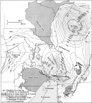
Illinois lies within the interior of the North American craton. The area of Illinois is a southern extension of the Canadian Shield; a thin northward-tapering wedge of Phanerozoic sedimentary rocks covers the Precambrian crystalline basement complex. Since Precambrian time, the cratonic interior has undergone relatively mild structural deformation, as compared with the severe folding and faulting produced along the continental margins during numerous mountain-building events. The largest structural features of the cratonic interior are broad gentle basins, arches, and domes that involve both basement and sedimentary cover (fig. 1).
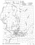
The Illinois Basin (also called the Eastern Interior Basin) covers roughly three-quarters of Illinois along with much of southwestern Indiana, a large area in western Kentucky, and small parts of Iowa, Missouri, and Tennessee (fig. 1). The east-west-trending Rough Creek-Shawneetown Fault System divides the Illinois Basin into two unequal parts (fig. 2). The large northern part includes the Fairfield Basin and its bordering shelves. The Fairfield Basin, which is oval with the long axis oriented north-south, contains approximately 15,000 feet (4,600 m) of sedimentary rocks at its deepest point. The Moorman Syncline, south of the Rough Creek-Shawneetown Fault System, is smaller than the Fairfield Basin but considerably deeper. As much as 23,000 feet (7,000 m) of layered rocks have been identified seismically near the north edge of the Moorman Syncline in Kentucky (Bertagne and Leising 1991). The strongly asymmetrical Moorman Syncline has a steep north flank and a very gentle south flank.
The Ozark Dome in southeastern Missouri, northern Arkansas, and a small area of extreme southwestern Illinois lies west of the southern part of the Illinois Basin. In Illinois, the boundary between the Ozark Dome and Illinois Basin is along the Ste. Genevieve Fault Zone and an associated monocline (fig. 2). Northward, the Du Quoin Monocline separates the Fairfield Basin from the Sparta Shelf. The gently sloping Sparta Shelf grades without definite boundaries to the northern Ozark Dome on the west and the Western Shelf on the north. North of the Ozark Dome, the Mississippi River Arch divides the Illinois Basin on the east from the Forest City Basin on the west (fig. 1).
The Wisconsin Arch extends southeast from central Wisconsin into northern Illinois, and borders the Illinois Basin on the north (fig. 1). The Kankakee Arch, which extends southeastward from the Wisconsin Arch, separates the Illinois and Michigan Basins. Farther east and south, the Cincinnati Arch divides the Illinois Basin from the Appalachian Basin. The Nashville Dome flanks the Moorman Syncline on the south. All of these arches and domes lack definite boundaries and grade through broad shelves into the adjacent basins.
The Pascola Arch (fig. 2) closes off the southwestern margin of the Illinois Basin between the Nashville and Ozark Domes (fig. 1). The Pascola Arch was uplifted some time after the middle of the Pennsylvanian Period and eroded, truncated, and buried beneath Upper Cretaceous and younger rocks in the Mississippi Embayment. The Embayment, as defined by the extent of Cretaceous rocks, reaches into southernmost Illinois and is a northern extension of the Gulf Coastal Plain.
The origin of intracratonic basins, arches, and domes is an enigma of geology. The processes responsible are obviously deep seated, slow acting, and not readily accessible to examination and comparison with modern analogues. Recent researchers such as Heidlauf et al. (1986) and Quinlan and Beaumont (1984) have attacked the problem through theoretical modeling. Testing of these models will require synthesis of vast amounts of stratigraphic and regional geophysical data. Kolata and Nelson (1991b) presented a review of recent findings and ideas.
Folds and Faults
Numerous folds, which are smaller in scale than regional basins, arches, and domes, as well as many fault zones and systems, have been described in Illinois. The more prominent folds and faults are discussed here and shown on figure 2 and plate 1. These features illustrate a variety of structural styles, including basement-seated normal and strike-slip faulting, basement-seated reverse faulting with folding of sedimentary cover, and detached folding and thrust faulting. There are structures of igneous origin, structures of probable impact origin, and domes due to differential compaction. In a number of cases, the same structure has undergone deformation under more than one stress regime.
Northern Illinois
As used here, northern Illinois is the area north of the limit of Pennsylvanian strata, which runs approximately from Rock Island to Joliet. Northern Illinois is underlain by Cambrian through Silurian bedrock on the crest and flanks of the Wisconsin Arch. Structures have been defined mostly on the basis of outcrop mapping (exposures are scarce because of glacial drift), water well records, and geophysical studies.
The largest structural features of northern Illinois are the Sandwich and Plum River Fault Zones (fig. 2). Both are zones of high-angle faults that have net downthrow to the north. On the Sandwich Fault Zone, maximum vertical displacement is about 800 feet (240 m). The crustal block between the Sandwich Fault Zone and the Peru Monocline (new) apparently was raised and tilted toward the southwest (Kolata et al. 1978). The timing of this movement is uncertain, but it was probably late in the Paleozoic Era. The west-trending Plum River Fault Zone has up to 400 feet of throw. It is flanked by gentle anticlines and domes on the south and synclines on the north (Kolata and Buschbach 1976). Research from Iowa indicates recurrent middle Paleozoic faulting; the principal movements occurred during the Devonian Period (Bunker et al. 1985). Kinematic analysis of stresses involved in the Plum River and Sandwich Fault Zones has been hindered by a lack of suitable exposures.
Several systems of high-angle normal and reverse faults, small folds, and joints have been described in the Upper Mississippi Valley Zinc-Lead District of northwesternmost Illinois, southwestern Wisconsin, and the adjacent part of Iowa (Heyl et al. 1959, Carlson 1961, Allingham 1963). Several episodes of extension, compression, and solution collapse may be involved. Geologists disagree on the interpretation of the origin of the various structures and any relationship to regional events.
The Des Plaines Disturbance northwest of Chicago is believed to be a post-Pennsylvanian astrobleme (Emrich and Bergstrom 1962, Buschbach and Heim 1972, McHone et al. 1986a, b). The Cook County Faults (new) have small displacements and uncertain affinities (Buschbach and Heim 1972).
Western Illinois
Western Illinois includes the Western Shelf and small areas of the Ozark Dome and Mississippi River Arch. Ordovician through Pennsylvanian bedrock dips regionally eastward toward the Fairfield Basin. The area west of the Illinois River has not been studied extensively because outcrop and well data are scarce. The quality and density of data improve for the areas to the east and south. Detailed structure maps, based on thousands of coal and oil test borings, are available for most of the Western Shelf south of Springfield.
The most conspicuous structures are northwest-trending anticlines and monoclines, such as the Valmeyer, Waterloo-Dupo, Pittsfield, and Fishhook Anticlines and the Cap Au Grès Faulted Flexure (fig. 2). Most of these structures are strongly asymmetrical; one limb dips a few degrees and the other dips 20° or steeper (locally overturned on the Cap Au Grès). The steep limbs of the Cap Au Grès, Waterloo-Dupo, and Media structures are faulted. All of these folds probably overlie faults in the Precambrian crystalline basement (Rubey 1952, Tikrity 1968, Gibbons 1972, Nelson and Lumm 1985).
Northwestern structural trends prevail not only in western Illinois, but through most of Missouri (McCracken 1971), eastern Kansas (Merriam 1963), and southeastern Iowa (Harris and Parker 1964). A strong northwestern grain, also apparent on gravity and magnetic maps of Missouri, indicates that surface faults and folds are rejuvenated Precambrian structures (Guinness et al. 1982, Braile et al. 1984, Kisvaranyi 1984).
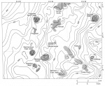
Small, nearly symmetrical, north-trending anticlines and numerous circular to irregularly shaped domes are present on the eastern Sparta Shelf from Bond and Madison Counties southward (fig. 3, plate 1). Not much is known about the anticlines. Many of the domes are products of draping and compaction over Silurian reefs. The St. Jacob Domes, and possibly other domes, overlie Precambrian Hills.
Farther north on the Western Shelf are several scattered domes of seemingly random orientation and distribution. Among these are the Hillsboro North and South, Waverly, Logan, Haw Creek, and Toulon Domes. Their origins and ages are unknown. The Glasford Structure south of Peoria probably is a pre-Cincinnatian (Late Ordovician) meteorite impact site (Buschbach and Ryan 1963, McHone et al. 1986b).
The Peoria Folds (new) in Fulton, Peoria, and neighboring counties are east-plunging anticlines and synclines of low relief (Wanless 1957). Drainage in the area closely corresponds with the fold axes; yet the origin and existence of these subtle structures remain in doubt.
Structure maps of Pennsylvanian coal seams in west-central Illinois show numerous minor irregularities having no preferred trend. Most of these irregularities probably resulted from differential compaction or similar nontectonic causes (see Removal of Names).
Eastern Illinois
The Fairfield Basin, La Salle Anticlinorium, Marshall-Sidell Syncline, and part of the northern flank of the Illinois Basin lie in eastern Illinois. The largest structures in this region are monoclines and asymmetrical anticlines that trend mostly north-south. The La Salle Anticlinorium is more than 200 miles (320 km) long and has as much as 2,500 feet (750 m) of vertical relief. The anticlinorium is a complex uplift that consists of branching, sinuous monoclines, most of which face west or southwest. Anticlines and domes are arranged like strings of beads along the upper limbs of the monoclines. Axial trends of individual folds commonly differ from the regional trend of the belt. The east-facing Du Quoin Monocline on the west side of the basin exhibits similar geometry on a smaller scale.
Other important north-trending folds are the Salem, Louden, Mattoon, and Clay City Anticlines. All of these structures experienced major uplift late in the Mississippian Period to early in the Pennsylvanian Period; also most of these continued to rise during and after the Pennsylvanian (Payne 1939, Du Bois 1951, Siever 1951, Clegg 1970). The folds appear to affect all Paleozoic rocks and probably overlie faults in basement, although published evidence of faulting is insufficient. Several of the largest oil fields in the Illinois Basin are developed in structural traps on these anticlines.
Circular to irregularly shaped domes are common in the Fairfield Basin, particularly in Clay and Hamilton Counties (plate 1). They range from about 1 to 4 miles (1.6-6.4 km) across and have up to 100 feet (30 m) of closure. Their distribution seems to be random and unrelated to major anticlines and monoclines. Drilling on the Hoodville and Dale Domes indicates Precambrian Hills. Several small domes in Marion County (plate 1, H-5, 6) overlie Silurian reefs. The origin of other domes is unknown.
Southern Illinois
Southern Illinois is the most intensely deformed region of the state. Structural styles include basement-rooted reverse, normal, and strike-slip faulting, as well as detached thrust faults and folds, and doming caused by igneous intrusion. Some faults have undergone recurrent movement in response to different stress regimes.
The Ste. Genevieve Fault Zone in southwestern Illinois and the adjacent part of Missouri comprises high-angle normal and reverse faults that reflect at least two major episodes of deformation. The southwest side of the fault zone was downdropped during an episode of normal faulting in Middle Devonian time (S. Weller and St. Clair 1928, Nelson and Lumm 1985). Later, in latest Mississippian and early Pennsylvanian time, the southwest block was uplifted in an episode of reverse faulting (Desborough 1961b, Nelson and Lumm 1985). The later episode of faulting induced strong monoclinal folding of strata along the fault zone.
The Lusk Creek Fault Zone and Rough Creek-Shawneetown Fault System also underwent multiple episodes of displacement. These faults originated as normal faults outlining the northwest and north margins of a Precambrian to early Cambrian rift zone (Soderberg and Keller 1981, Nelson and Lumm 1987, Bertagne and Leising 1991). The fault zones were reactivated as high-angle reverse faults late in the Paleozoic Era. This structural inversion probably accompanied the Alleghenian Orogeny. A second episode of normal faulting followed reverse faulting; the southeastern block collapsed, and slices of the hanging wall were sheared off and left high within the fault zone (Smith and Palmer 1974). The steep north limb of the Eagle Valley Syncline also developed during downward movement of the southeast block (Nelson and Lumm 1987).
The Fluorspar Area Fault Complex (plates 1 and 2), southeast of the structures described above, contains intricate zones of high-angle faults, most of which strike northeast. The displacements are predominantly normal, but some faults exhibit reverse and oblique slip. Mine exposures indicate multiple episodes of faulting and mineralization. These faults have undergone movement from Mississippian through Tertiary time, but the largest displacements are believed to be early Mesozoic (Kolata and Nelson 1991a).
The Wabash Valley Fault System north of the Rough Creek-Shawneetown is composed of high-angle normal faults having up to 480 feet (145 m) of throw (Bristol and Treworgy 1979, Ault et al. 1980). The relationship of the fault system to the Fluorspar Area Fault Complex is unclear. Braile et al. (1984) and Sexton et al. (1986) proposed that the Wabash Valley Fault System represents reactivated basement faults of a Precambrian rift system. Seismic data indicate no rift structure in the area, however, and they show that some of Wabash Valley faults die out at depth (Pratt et al. 1989, Nelson 1990).
The east-trending Cottage Grove Fault System is a right-lateral wrench fault that developed late in the Pennsylvanian to early in the Permian Period (Clark and Royds 1948, Nelson and Krausse 1981). Considered by some to be a westward continuation of the Rough Creek-Shawneetown Fault System, the Cottage Grove exhibits a different structural style and history; however, both fault systems may follow a Precambrian shear zone (Heyl 1972).
Hicks Dome is a large, nearly circular, fractured dome in the Fluorspar Area Fault Complex. It has been labeled cryptovolcanic and is thought to be the product of explosive igneous activity at depth (Brown et al. 1954, Bradbury and Baxter 1992). Numerous dikes, small stocks, and diatremes of ultramafic rocks and breccia occur near Hicks Dome. They appear to radiate from the dome and· are concentrated along an axis that trends north-northwest. Similar dikes occur within the eastern part of the Cottage Grove Fault System and sills underlie Omaha Dome. Ultramafic rocks from the Cottage Grove and from near Hicks Dome have been radiometrically dated as Early Permian (Zartman et al. 1967).
Figure(s)
|


