Pascola Arch
Location
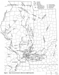
See text below and figure 2

References
Freeman 1949, Grohskopf 1955, Stearns and Marcher 1962, Tikrity 1968, McCracken 1971, Schwalb 1971, 1982, Atherton 1971, Houseknecht 1983
Description
Wilson (1939) suspected the existence of an eroded and buried structural high in the northern Mississippi Embayment, but borehole and geophysical data were not available then to prove it. Freeman (1949) confirmed the existence of the high, but considered it to be part of the Ozark Dome. Grohskopf (1955) showed the high to be separate from the Ozark Dome and named it the Pascola Arch.
Schwalb (1982) mapped the Pascola Arch as a roughly circular domal uplift, covering approximately 15,000 square miles (38,000 km) and centered in the 'bootheel" of Missouri.
As interpreted by the authors cited above and by Steams and Marcher (1962), the Pascola Arch is a pre-Cretaceous structure. Paleozoic strata were upwarped, eroded, and truncated with angular unconformity by the Tuscaloosa Gravel (Upper Cretaceous) in the Mississippi Embayment. Cambrian rocks are directly overlain by Tuscaloosa at the apex of the arch. The northeast dip of Paleozoic strata and southern closure of the Illinois Basin in southernmost Illinois are attributed to the Pascola Arch.
Recent geophysical data and subsurface mapping have revealed a sharply upwarped, northeast-trending linear anticline in the northern Mississippi Embayment. This structure, called the Blytheville Anticline or Charlie's Ridge, has been variously interpreted as a positive flower structure created by wrench faulting (Howe and Thompson 1984) or as a diapir that formed under tensional stress (McKeown et al. 1991). Some of the wells used by early researchers to interpret the Pascola Arch are located along the Blytheville Anticline. McKeown et al. (1991) questioned the existence of the Pascola Arch, interpreting the structural high in the bootheel as part of the Blytheville Anticline. Vincent T. Larson (personal communication 1991), who has extensively studied borehole and seismic data from the Mississippi Embayment, also believes that the Pascola Arch as originally conceived does not exist. Nevertheless, regional outcrop and subcrop patterns of Paleozoic rocks indicate a regional uplift larger than the Blytheville Anticline and centered in southeast Missouri. A recent map by Dennis R. Kolata (1993, unpublished data) depicts the Pascola Arch as a broad, southeast-trending nose off the Ozark Dome. The narrow Blytheville Anticline crosses this structure at right angles. Thus, presence of the Pascola Arch seems to be confirmed, although the nature and tectonic history of this feature requires further study.
See also REELFOOT RIFT.
