Eagle Valley Syncline
Part of the Rough Creek-Shawneetown Fault System
Location
Southeastern Saline and southern Gallatin Counties (J-7)
References
Butts 1917, 1925, S. Weller et al. 1920, Cady 1952, Smith 1957, Heyl et al. 1965, Baxter et al. 1967, Nelson and Lumm 1987, 1986a, b, c
Description
The name Eagle Valley Syncline is applied to the narrow western extension of the Moorman Syncline in Illinois. The Eagle Valley Syncline lies immediately south of and trends approximately parallel with the east-west part of the Shawneetown Fault Zone. As defined, the Eagle Valley Syncline is about 15 miles (24 km) in length, and its width increases from about 6 miles (10 km) near the west end to about 9 miles (15 km) at the Ohio River. It is abruptly closed off at the west end, where the Shawneetown Fault Zone turns to the southwest. The flanks are marked by rugged hills of resistant lower Pennsylvanian sandstone, whereas the central area is a lowland underlain by easily eroded Desmoinesian and younger Pennsylvanian strata.
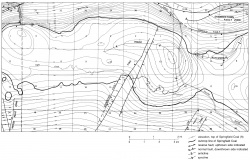
Detailed structural mapping by Nelson and Lumm (1987, 1986a, b, c), as measured on the Springfield Coal Member, reveals more than 2,000 feet (600 m) of relief in the syncline (fig. 34). The axis is sinuous and contains several enclosed depressions. The south limb dips rather uniformly at 5° to 10°; dips on the north limb are much more variable, from less than 10° to 60° (locally steeper).
The north limb of the Eagle Valley Syncline is a strong drag fold or fault propagation fold that was produced by displacement along the Rough Creek-Shawneetown Fault System. The south flank of the syncline merges with the north flank of Hicks Dome and the northeast flank of the Tolu Arch.
