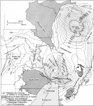
Mississippi Embayment
Location
Southernmost Illinois and southward along Mississippi Valley (fig. 1)

References
(selected) Pryor and Ross 1962, Ross 1963, 1964, Kolata et al. 1981
Description
The Mississippi Embayment is a northward extension of the Gulf Coastal Plain. It is a broad synclinal trough filled with Mesozoic and Cenozoic sedimentary rocks. In southernmost Illinois the Embayment contains poorly lithified Upper Cretaceous, Paleocene, and Eocene strata that unconformablv overlie Paleozoic sedimentary rocks and unconformably underlie the Pliocene-Pleistocene Mounds Gravel and Quaternary alluvium. The limit of the Embayment is generally drawn at the north edge of the Cretaceous rocks.
The Reelfoot Rift, a Cambrian fault-bounded trough, was ancestral to the Mississippi Embayment. Faults in the [[Reelfoot Rift]] have been reactivated periodically throughout Phanerozoic time. In late Paleozoic or early Mesozoic time uplift occurred along the axis of the rift, and a large domal uplift called the Pascola Arch developed. The Pascola Arch was beveled by erosion prior to Late Cretaceous time, when the northern Mississippi Embayment began to subside. The Cretaceous Tuscaloosa Gravel overlies beveled Paleozoic rocks with angular unconformity at the site of the Pascola Arch.
Tectonic activity took place throughout the Tertiary Period in the northern Mississippi Embayment and continues today. Post-Cretaceous faulting was documented in parts of western Kentucky (Rhoades and Mistler 1941, Amos 1967, Amos and Finch 1968) and southeastern Missouri (Grohskopf 1955, McCracken 1971, W. Johnson 1985) immediately adjacent to Illinois. Kolata et al. (1981) disputed Ross's (1963) claims of post-Cretaceous tectonism in southernmost Illinois; but recent mapping has vindicated Ross. Tectonic faults that displace units ranging from the Tuscaloosa Gravel to the Mounds Gravel occur in the Thebes area (Harrison and Schultz 1992, Nelson and Harrison 1993), the Jonesboro-Mill Creek area (Nelson and Devera 1994, Devera et al. 1994), and in the southern Dixon Springs Graben (W.J. Nelson, ISGS, unpublished mapping).
The New Madrid Seismic Zone, which begins near Cairo, Illinois, and extends southwest, is the most active earthquake region in the central United States. Faults inherited from the Reelfoot Rift are being reactivated under contemporary tectonic stress in the New Madrid Seismic Zone. The principal compressive stress in the New Madrid area is oriented from east-west to east-northeast to west-southwest, and the principal active faults strike northeast and are undergoing right-lateral slip. Some faults that were active during the Tertiary in southernmost Illinois exhibit the same trend and slip (Nelson and Harrison 1993). As of 1993, no Quaternary displacements have been demonstrated along faults in the Mississippi Embayment in Illinois.
