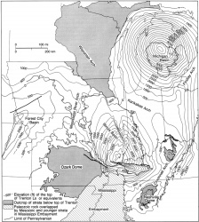
Kankakee Arch
Location
Northeastern Illinois and north-central Indiana (fig. 1)

References
Pirtle 1932, Ekblaw 1938, Willman and Payne 1942, Workman and Bell 1948, Willman and Templeton 1951, Green 1957, Bell et al. 1964, Atherton 1971, Fisher and Barratt 1985, Treworgy and Whitaker 1990b
Description
The Kankakee Arch separates the Illinois Basin from the Michigan Basin. It is a broad divide or saddle connecting the Wisconsin Arch on the northwest with the Cincinnati Arch on the southeast. The limits of the Kankakee Arch are not precisely defined because dips on its flanks are extremely gentle.
The Kankakee Arch first came into being late in the Canadian Epoch. Figure 44 shows that the Prairie du Chien Group is arched and truncated by erosion beneath the St. Peter Sandstone. The St. Peter thins across the arch and nearly pinches out. The overlying Platteville Group (Blackriveran) also thins. The Ordovician Kankakee Arch lay slightly northeast of the current arch (Atherton 1971). During the Silurian Period, the arch became the scene of reef development between the deeper seas to the north and south. By the Middle Devonian Epoch, the division became almost complete between the Illinois and Michigan Basins; evaporites were deposited in the latter. Not much is known about subsequent development because post-Devonian rocks have been eroded from the arch. Mississippian and Pennsylvanian sediments at least partially overlapped the Kankakee Arch, as shown by the presence of rocks of that age in the Des Plaines Disturbance, which lies on the north flank of the arch.
References
Figure(s)
|

