Moorman Syncline
Location
Southeastern Illinois and western Kentucky (fig. 1)

References
Hager 1949, Swann and Bell 1958, Smith and Palmer 1974, Schwalb 1979, Nelson and Lumm 1987
Description
The origin of the name Moorman Syncline is obscure. Swann and Bell (1958) probably were not the first to use the term, but they did not cite earlier usage. Hager (1949) referred to the feature as the Kentucky Basin. Considering the regional extent of the structure, Moorman Basin might be a more appropriate name than Moorman Syncline, but the latter name is solidly established by common usage.
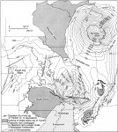
The Moorman Syncline lies south of and trends almost parallel with the Rough Creek-Shawneetown Fault System. The north flank is defined by strata sharply upturned against the south side of the Rough Creek-Shawneetown Fault System. The south limb corresponds with the gentle north flank of the Nashville Dome. The syncline terminates eastward against the Cincinnati Arch, whereas it is pinched out on the west between Hicks Dome and the southwest-trending segment of the Shawneetown Fault Zone. The narrow western end of the trough in Illinois is commonly called the Eagle Valley Syncline.
The Moorman Syncline actually is a sub-basin within the Illinois Basin and comparable with the Fairfield Basin. Both structures are bounded partly by sedimentary shelves or arches and partly by post-Pennsylvanian fault zones or monoclines. No separation existed between the Fairfield Basin and Moorman Syncline prior to late Pennsylvanian-Permian uplift along the Rough Creek-Shawneetown Fault System. Development of the Moorman Syncline in its present form apparently resulted from subsidence and collapse of the block south of the fault system, probably in the Mesozoic Era (Nelson and Lumm 1987).
The Moorman Syncline overlies the Rough Creek Graben, a Cambrian fault-bounded trough. The syncline contains the thickest (as much as 25,000 feet of Paleozoic sediment, according to estimates from seismic data) and most complete sedimentary succession in the Illinois Basin. This succession includes the oldest rocks that are approximately 8,000 feet (2,400 m) of pre-Mt. Simon strata. It also includes the youngest Paleozoic rocks, Lower Permian, identified in a core in western Kentucky (Kehn et al. 1982).
