Lusk Creek Fault Zone
Part of the Fluorspar Area Fault Complex
Location
From western Massac to northeastern Pope County (K-6, 7 and pl. 2)
References
S. Weller and Krey 1939, J. Weller 1940, J. Weller et al. 1952, Heyl et al. 1965, Baxter et al. 1967, Kolata et al. 1981, Klasner 1982, Nelson 1986, Nelson and Lumm (1987), Nelson et al. 1991, Bertagne and Leising 1991, Weibel et al. 1993
Description
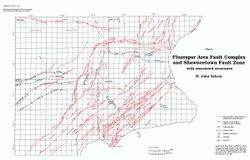
The Lusk Creek Fault Zone marks the northwest boundary of the Fluorspar Area Fault Complex, and it is the northwestern-most structure along which fluorspar has been mined. The zone extends southwestward from the southern end of the Shawneetown Fault Zone in Section 25, T11S, R6E, Pope County, into western Massac County, where it disappears beneath the Quaternary alluvium. The northeastern continuation of the Lusk Creek Fault Zone is known as the Herod Fault Zone. The Lusk Creek Fault Zone forms the northwest margin of the Dixon Springs Graben.
The Lusk Creek Fault Zone is composed of subparallel, high-angle normal and reverse faults. Width of the fault zone varies from a few hundred feet to almost 1 mile (1.5 km). Cumulative displacement averages roughly 500 feet (150 m) down to the southeast, but local displacements on individual faults may be as great as 1,500 feet (450 m). The fault zone dips approximately 70° to the southeast near the surface.
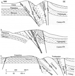
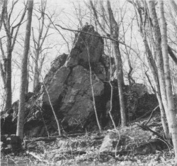
The Lusk Creek Fault Zone appears to have undergone at least three major episodes of movement. The first was during Early Cambrian time when the Reelfoot Rift developed. A seismic reflection profile (Bertagne and Leising 1991) indicates that this was an episode of normal faulting. The southeast side of the fault zone was downthrown, allowing thicker accumulation of sediment on the southeast. The second episode in late Pennsylvanian to Permian time was compressional and resulted in reverse faulting. The third episode (early Mesozoic?) was again normal faulting, which canceled the reverse movement. Slices of rock raised during reverse faulting have remained high within the fault zone at several places (fig. 47). The most striking example is at CLay Diggings (NE SE, Section 16, T12S, R6E) where a central slice of Ste. Genevieve Limestone is juxtaposed with upper Chesterian strata on the northwest and Pennsylvanian rocks on the southeast (Weibel et al. 1993). The final episode of normal faulting sharply dragged and tilted the layers down to the southeast all along the fault zone (fig. 48). The Dixon Springs Graben is a product of the last movement (Nelson 1986, Nelson et al. 1991, Weibel et al. 1993).
This inferred sequence of movement is the same as that proposed by Nelson and Lumm (1987) for the Shawneetown Fault Zone, which connects with the Lusk Creek Fault Zone.
Several small fluorspar mines operated within the Lusk Creek Fault Zone during the 1940s and earlier. Most of these worked at stratigraphic levels higher than those of the richest deposits farther southeast. Deeper exploration along the Lusk Creek Fault Zone might yield additional reserves.
See also DIXON SPRINGS GRABEN.
References
Figure(s)
|


