Fairfield Basin
Location
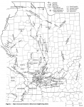
Southeastern Illinois (fig. 2)

References
Bell et al. 1964, Allgaier and Hopkins 1975
Description
The name Fairfield Basin is frequently used to describe the central, deep part of the Illinois Basin within Illinois. The Du Quoin Monocline on the west, the La Salle Anticlinorium on the northeast, and the Rough Creek-Shawneetown Fault System and Cottage Grove Fault System on the south, respectively, are generally taken as boundaries of the Fairfield Basin. The north and northwest boundaries are indefinite.
The Fairfield Basin was not a sedimentary basin, and it did not exist during most of the Paleozoic Era. The structural movements responsible for the basin began late in the Chesterian Epoch (Mississippian) and culminated after Pennsylvanian sedimentation. The basin subsided more rapidly than surrounding shelves during Pennsylvanian time, but the region was open to the southwest and north of the Ozark Dome. Principal drainage passed through to the Arkoma Basin. Southern closure, caused by uplift of the Pascola Arch, did not commence until the Desmoinesian Epoch (Pennsylvanian) at the earliest (Houseknecht 1983).
The Fairfield Basin is roughly oval in outline and lacks a well defined axis. The lowest points structurally are irregular depressions in northeastern Hamilton and northwestern White Counties. Within the Fairfield Basin are numerous anticlines and synclines, most of which trend north to south, with many circular or irregular domes. The most prominent anticlines are the Salem, Louden, and Clay City structures. These anticlines probably all overlie faults in Precambrian crystalline basement. The origin of most domes is unknown; however, the Omaha Dome was formed by igneous intrusion. The Dale and Hoodville Domes probably overlie Precambrian hills, and several domes in Marion and Cumberland Counties overlie Silurian reefs. High-angle normal faulting is present in the Wabash Valley Fault System and Rend Lake Fault Zone.
Although the Fairfield Basin contains the geographic center of the Illinois Basin, it does not contain the structurally lowest point, the youngest rocks, or the thickest total sedimentary succession. All of these are found in western Kentucky, south of the Rough Creek-Shawneetown Fault System. In the deepest part of the Fairfield Basin, in northeastern Hamilton County, the Springfield Coal Member (Pennsylvanian) is 786 feet (240 m) below sea level (Hopkins 1968). The same coal is more than 1,050 feet (315 m) below sea level in southeastern Webster County, Kentucky (Tennessee Valley Authority 1969). The youngest Paleozoic bedrock in Illinois is of Virgilian (late Pennsylvanian) age in Cumberland County, approximately 75 miles (120 km) north of the structural low point of the Fairfield Basin (Weibel 1986). Permian strata were identified in a drill core from a graben in western Kentucky (Kehn et al. 1982). The maximum total thickness of Paleozoic strata in the Fairfield Basin is approximately 15,000 feet (4,600 m), as compared with 23,000 feet (7,000 m) or more in Kentucky south of the Rough Creek-Shawneetown Fault System (Bertagne and Leising 1991).
Most of the oil production in Illinois is from anticlinal, domal, and stratigraphical traps in the Fairfield Basin. The three largest oil fields in the Fairfield Basin are on the Salem, Louden, and Clay City Anticlines. Cumulative production from these three fields is more than a billion barrels of oil.
