Rough Creek-Shawneetown Fault System
Location
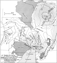
Northeastern Pope, southeastern Saline, and Gallatin Counties, Illinois (J-6, 7); eastward to Grayson County, Kentucky (fig. 1)

References
(selected) Owen 1856, Norwood 1876, Brokaw 1917, Butts 1925, J. Weller 1940, Clark and Royds 1948, Freeman 1951, Sutton 1953, 1971, Heyl and Brock 1961, Heyl et al. 1965, Heyl 1972, Davis et al. 1974, Schwalb 1979, 1982, Smith and Palmer 1974, Krausse et al. 1979, Soderberg and Keller 1981, Nelson and Lumm 1987, Bertagne and Leising 1991, Sargent et al. 1992
Description
Confusing nomenclature has arisen because segments of this fault system were named before its full extent was known. The name Shawneetown Fault dates back to Owen (1856) and has been generally applied to that part of the fault system in Illinois. Although Gold Hill Fault appears in some old reports, that name has not been used for more than 70 years. The name Rough Creek originated with Norwood (1876) and has been used by most researchers in Kentucky. Because both names are established, the compound form Rough Creek-Shawneetown Fault System is chosen to refer to the entire system. It is designated a fault system rather than a fault zone because it contains a complex arrangement of normal, reverse, and strike-slip faults reflecting at least three separate episodes of movement.
The western end of the Rough Creek-Shawneetown Fault System is in northeastern Pope County, Illinois, where the fault system intersects the Lusk Creek Fault Zone. This part of the Rough Creek-Shawneetown Fault System trends north-northeast for about 12 miles (19 km) into southeastern Saline County, where it turns sharply to the east. It continues eastward with a slightly sinuous course as far as Grayson County, Kentucky, where it turns southeastward, branches, and dies out. The total length of the Rough Creek-Shawneetown Fault System is about 130 miles (210 km).
The fault system exhibits a complex braided pattern in map view. The system is widest, more than 5 miles (8 km) in places, in Union, Webster, and McLean Counties, Kentucky. It narrows to about 1 mile (1.6 km) at the Illinois-Kentucky border. Westward, only a single fault has been mapped in some places. East of McLean County, Kentucky, the Rough Creek-Shawneetown Fault System also becomes narrower and loses displacement.
In cross section view the Rough Creek-Shawneetown generally takes the form of a complex arched series of horsts or a faulted anticline in near-surface strata. Although blocks within the fault system are upthrown hundreds or thousands of feet, little relative vertical displacement takes place across the fault system in post-Cambrian strata. Rocks north of the Rough Creek-Shawneetown Fault System typically are horizontal or gently dipping and only slightly deformed. Strata south of the Rough Creek-Shawneetown Fault System dip at 10° to 25°, and locally much steeper, into the Eagle Valley-Moorman Syncline. Rocks within fault slices dip at various attitudes, but most are tilted southward, commonly at 45° or steeper. An anticlinal structure is more prevalent in the eastern half of the system. Grabens also are present; one graben in Kentucky contains the only known Permian strata in the Illinois Basin (Kehn et al. 1982).
Drilling, outcrop studies, and seismic reflection profiles indicate that the largest near-surface fault of the Rough Creek-Shawneetown Fault System is a reverse fault. It generally crops out at or near the north edge of the Rough Creek-Shawneetown Fault System and was designated the front fault by Nelson and Lumm (1987). The front fault dips southward 60° or steeper in most places, although near Morganfield, Kentucky, it dips as gently as 25° (Smith and Pahner 1974). Most of the other faults in the system are normal. Seismic profiles indicate that they intersect the front fault at or above the upper Cambrian Eau Claire Formation (Bertagne and Leising 1991).
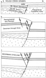
Seismic data (Bertagne and Leising 1991 and proprietary seismic lines viewed by the author) demonstrate that near surface faults of the Rough Creek-Shawneetown Fault System follow the north boundary of an Early Cambrian graben. The existence of this Rough Creek Graben previously was inferred from gravity and magnetic data, as well as scattered information from deep wells (Soderberg and Keller 1981, Schwalb 1982). The north boundary fault of the Rough Creek Graben is a listric normal fault that penetrates crystalline basement (fig. 62). Displacement along this fault is as great as 8,000 feet (2,400 m) and the south side is downthrown. The Rough Creek Graben was filled with a thick sequence of layered rocks prior to deposition of the Eau Claire Formation (Upper Cambrian).
The importance of the Rough Creek Graben in tectonic evolution of the Illinois Basin is discussed further in the section on Structural History. Some geologists, including Clark and Royds (1948), Heyl and Brock (1961), Heyl et al. (1965), and Heyl (1972), inferred wrench faulting along the Rough Creek-Shawneetown Fault System. The braided pattern of faults in map view and the narrow upthrust slices along the fault zone are typical features of strike-slip faults. Several lines of evidence, most notably the lack of offset of pre-Pennsylvanian paleochannels that cross the Rough Creek-Shawneetown Fault System in Kentucky (Davis et al. 1974), seem to rule out large post-Pennsylvanian horizontal displacements. Nelson and Lumm (1987) and Bertagne and Leising (1991) proposed that in the Permian or late in the Pennsylvanian Period, the northern boundary fault of the Rough Creek Graben was reactivated as a reverse fault under compressional stress (fig. 62). This event raised the southern block of the front fault. A later episode of extension allowed the southern block to drop back to its earlier position. As the southern block dropped, many slices of rock were sheared off the hanging wall and left high within the fault zone, while strong drag on the descending block produced the northern limb of the Eagle Valley-Moorman Syncline (fig. 62).
References
Figure(s)
|

