Jones Fault Zone
Part of the Rough Creek-Shawneetown Fault System
Location
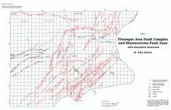
Section 11, T10S, R7E, Saline County to Section 6, T10S, R8E, Gallatin County (pl. 2)

References
Nelson and Lumm 1987
Description
The Jones Fault Zone lies 1 to 1.5 miles (1.6--2.4 km) southeast of the front fault of the Rough Creek-Shawneetown Fault System, and it strikes parallel with the fault system at the northwest end of the Eagle Valley Syncline. The Jones Fault Zone is a complex, narrow fault zone or faulted flexure that has net displacement down to the southeast. Coal test boreholes along its trend show both missing and repeated intervals of strata. A roadcut made in 1986 just east of Glen O. Jones Lake reveals complexly faulted Pennsylvanian sandstone and shale (fig. 42). Three large faults and many small ones are exposed in this cut. The large faults are high-angle normal, and they strike east-northeast to east. Slices of rock between the faults have been rotated and are displaced by small, low-angle normal faults.
