Winkleman Fault
Location
T10S, R6E, Saline County, and T11S, R6E, Pope
County (J-6, and pl. 2)
References
Cady 1926, Nelson et al. 1991
Description
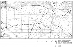
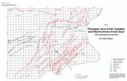
Cady (1926) mapped the Winkleman Fault on the basis of outcrops. He showed the fault as trending northeastward for about 3 miles (5 km) in Saline County and having the southeast side downthrown. New geologic mapping (Nelson et al. 1991) indicates that the Winkleman Fault is part of a complex zone of faulting associated with the McCormick and New Burnside Anticlines. The part recognized by Cady approximately follows the axis of the New Burnside Anticline and is a high-angle fault with the southeast side downthrown about 100 feet (30 m). The fault can be traced southwestward into Pope County, where it diagonally connects the New Burnside and McCormick Anticlines. The structure is complex in Section 5, T11S, R6E, where displacements may exceed 200 feet (60 m). The fault, which dies out about 1.5 miles (2.5 km) southwest of Section 5, has a total mapped length of about 7 miles (11 km).

