Pisgah Syncline
From ILSTRUC
Part of the Eagle Valley Syncline
Location
From Section 10, T10S, R8E, to Section 18, T10S, R9E, Gallatin County (pl. 2)

References
Nelson and Lumm 1987
Description
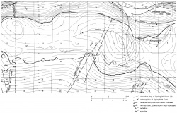
The Pisgah Syncline is a deep enclosed depression within the Eagle Valley Syncline, which in this area consists of several irregular basins and synclines separated by saddles. The axis of the Pisgah Syncline curves sharply from east-northeast to south and is about 4 miles (6 km) long (fig. 34). More than 200 feet (60 m) of internal closure is mapped on the Springfield Coal Member (Pennsylvanian). The outline of the Pisgah Syncline, shown on plate 2, is the area of internal closure.

