Lawler Fault
Part of the Rough Creek-Shawneetown Fault System
Location
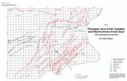
Section 27, T9S, R8E, to Section 31, T9S, R9E, Gallatin County (pl. 2)
References
Strunk 1984, Nelson and Lumm 1987
Description
The name Lawler Fault is used here for the structure that was originally named the Negro Spring Fault (Strunk 1984). The small community of Lawler lies close to the fault trace.
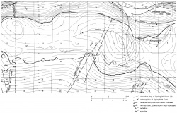
The Lawler Fault was mapped by Nelson and Lumm (1987) on the basis of well data. It is north of the front fault of the Shawneetown Fault Zone and strikes N70°W. Maximum throw is 250 to 300 feet (75-90 m) down to the south. One well penetrated the fault; a missing section indicated two closely spaced normal faults. Strunk (1984) inferred, on the basis of a gravity survey, that the Lawler Fault may join the east end of the Cottage Grove Fault System.
I recently remapped the Lawler area using records of wells drilled since 1987. The new data indicate that the Lawler Fault is approximately ½ mile north of where it was mapped by Nelson and Lumm (1987). Oil in the Lawler oil field is trapped in a tilted block that is bounded on the southwest by the Lawler Fault.
Saline springs along the foot of the Wildcat Hills, a short distance south of the Lawler Fault, formed the basis for an important pioneer industry. Before Illinois became a state, slaves were brought in to gather and boil brine from the springs to make salt. Saline County owes its name to the saline springs.

