Kuykendall Anticline
From ILSTRUC
Location
Northwestern T10S, R9E, Gallatin County (pl. 2)

References
Nelson and Lumm 1987
Description
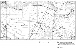
Mapped from dozens of coal test drill holes, the Kuykendall Anticline lies between the Rough Creek-Shawneetown Fault System and the sinuous axis of the Eagle Valley Syncline (fig. 34). The axis of the Kuykendall Anticline curves from the east to the northeast and is a little more than 2 miles (3 km) long. Closure of more than 100 feet (30 m) is mapped on the Springfield Coal Member (Pennsylvanian).

