Herod Fault Zone
Part of the Fluorspar Area Fault Complex
Location
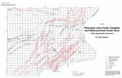
From Section 25, T11S, R6E, Pope County, to Section 24,T10S, R7E, Saline County (pl. 2)

References
Butts 1917, S. Weller et al. 1920, J. Weller et al. 1952, Baxter et al. 1967, Nelson and Lumm 1987
Description
The Herod Fault Zone is a northeastern extension of the Lusk Creek Fault Zone. As mapped by Baxter et al. (1967), the Herod Fault Zone contains from one to as many as five subparallel, interconnected faults. Southwest of Herod the net displacement is down to the southeast, but northeast of Herod the direction of throw reverses. This zone is thought to be composed entirely of high-angle normal faults. Several normal faults are exposed on coal mine highwalls near the northeastern end of the zone (Nelson and Lumm 1987). A body of igneous breccia was mapped adjacent to the Herod Fault Zone in the NW SE, Section 19, T11S, R7E (Baxter et al. 1967).
