Grindstaff Fault Zone
Part of the Fluorspar Area Fault Complex
Location
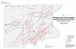
T10S, R8E, Gallatin County (pl. 2)
References
Butts 1925, Smith 1957, Baxter and Desborough 1965, Nelson and Lumm 1986b, 1987
Description
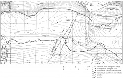
Butts (1925) named the Grindstaff Fault and depicted it as striking N25°E from the Gallatin-Hardin county line (the south edge of his map) to Section 2, T10S, R8E. He showed it as a single fault with the southeast side downthrown a maximum of about 200 feet (60 m). Smith (1957) mapped the Grindstaff Fault essentially as shown by Butts. Nelson and Lumm (1986b, 1987), using borehole data not available to Butts or Smith, found evidence for three faults and renamed the structure Grindstaff Fault Zone. The three faults are parallel and produce a horst and a graben (fig. 34). They are concealed by alluvium in Eagle Valley, but the linear trend of Grindstaff Hollow may be controlled by associated fractures. The northern extent is unknown; the zone may reach the Shawneetown Fault Zone. Nelson and Lumm (1986b, 1987) and Baxter and Desborough (1965) found no evidence to extend the fault zone south of Section 28, T10S, R8E, Gallatin County.

