Wolrab Mill Fault Zone (New Name)
Part of the Fluorspar Area Fault Complex
Old Name: Wolrab Mill Fault
Location
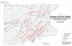
Section 14, T12S, R7E, to Section 28, T10S, R9E,
Hardin County (pl. 2)

References
S. Weller et al. 1920, J. Weller et al. 1952, Brown et al. 1954, Palmer 1956, Baxter et al. 1963, Baxter and Desborough 1965, Baxter et al. 1967
Description
Although the structure is poorly defined, the name has recurred in the literature. Wolrab Mill Fault Zone is a more appropriate name than the Wolrab Mill Fault. This zone of northeast-trending faults lies in the upthrown block between the Dixon Springs and Rock Creek grabens and extends from the Stewart Fault near the Hardin-Pope county line northeast to the Ohio River bottomlands. Individual faults in the zone have throws ranging from about 30 feet (10 m) to several hundred feet down to either the northwest or the southeast. Although shown on some maps as extending southwest beyond Bay Creek in Pope County, no evidence of the Wolrab Mill Fault Zone was observed in extensive workings along the Stewart vein (S. Weller et al. 1920, J. Weller et al. 1952).

