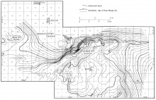
Wine Hill Dome
From ILSTRUC
Location
Northern T7S, R5W, Randolph County (J-4)
References
Root 1928, Nelson and Krausse 1981
Description
Root (1928) mapped the Wine Hill Dome on the basis of scanty outcrop data. The dome was depicted as elongated slightly north of east, about 2 miles (3 km) long, and less than 1 mile (1.6 km) wide (fig. 22). Root (1928) inferred a fault south of the crest of the dome. The dome cannot be defined any better today than when Root's report was published, but Nelson and Krausse (1981) speculated that it may reflect a westward extension of the Cottage Grove Fault System.
