Campbell Hill Anticline
Part of the Cottage Grove Fault System
Location
Northwestern Jackson County (J-4, 5)
References
Shaw 1910, St. Clair 1917b, Root 1928, S. Weller and J. Weller 1939, Nelson and Krausse 1981
Description
The most thorough description and best map of the Campbell Hill Anticline were done by Root (1928), who employed both surface and subsurface information. Little drilling has taken place in the area since 1928.
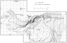
Root's map was contoured partly on the Herrin Coal Member and partly on the "Ava shale," a local marker bed in the lower part of the Pennsylvanian. The map (fig. 22) shows an elongate fold that is about 15 miles (24 km) long and has several separate areas of closure. The axis of the western part of the fold trends N55°E; eastward, it curves to the east. The northwest limb is steeper than the southeast and has greater structural relief, more than 300 feet (90 m). Several small faults, all trending northwestward, were mapped at the surface on the northwest flank of the anticline.
The master fault of the Cottage Grove Fault System follows the north flank of the Campbell Hill Anticline, and the western part of the anticline lies in en echelon relation to the fault. This implies that the anticline is a product of right-lateral wrenching along the fault zone (Nelson and Krausse 1981).
The Ava-Campbell Hill Oil and Gas Field was developed in structural traps on the Campbell Hill Anticline. Production, chiefly gas, was obtained from the Cypress Sandstone (Mississippian). The field was discovered in 1916, abandoned in 1943, and briefly revived in 1956-1957. Cumulative production is listed as 25,000 barrels of oil and an unknown quantity of gas.
Figure(s)
|
